Tersus Broadens its Offer with Inertial Navigation System
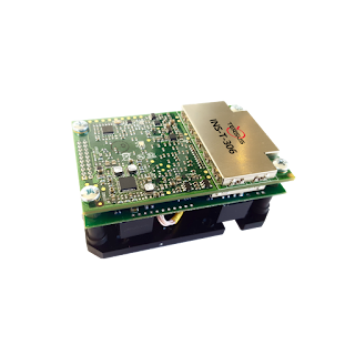
Tersus GNSS Inc. (“Tersus”), a leading GNSS manufacturing company presents a new product in its offer. The INS-T-306, GNSS-Aided Inertial Navigation System, is the advanced module which combines GPS L1/L2, GLONASS, BDS navigation and high-performance strapdown system. It is capable to determine position, velocity and absolute orientation (heading, pitch and roll) for any device on which it is mounted.
The launch of this INS unit aims at facilitating the motionless and dynamic applications which need high accuracy, such as vessels, ships, helicopters, UAVs, UGVs, etc.
 |
| GNSS-Aided Inertial Navigation System (INS-T-306) |
INS-T-306 utilizes advanced GNSS receiver, barometer, magnetometers, MEMS accelerometers and gyroscopes to provide accurate position, velocity, heading, pitch and roll of the device under measure. It supports GPS L1/L2, GLONASS, BDS, DGPS, RTK. It is able to integrate into LiDAR (Velodyne, RIEGL, FARO). With on-board sensor fusion filter, state-of-the-art navigation and guidance algorithms and calibration software inside, all make INS-T-306 commercially exportable GNSS-aided inertial navigation system.
More details:
About Tersus GNSS
Tersus GNSS provides real-time, centimeter-level accurate and cost efficient Global Navigation Satellite System (GNSS) positioning solutions. Designed for easy and rapid integration, our GNSS product lines, the Precis GNSS RTK boards and receivers, offer high-precision capability as well as flexible interfaces for a variety of applications, such as unmanned aerial vehicle (UAVs), surveying, mapping, precision agriculture, crop health monitoring, agricultural remote sensing, lane-level navigation, construction engineering, and deformation monitoring, etc.
Comments
Post a Comment