
Tersus Releases GeoCaster Software, a Cost-effective Caster Software for NTRIP Corrections

Shanghai, Jan 10, 2019 - Tersus GNSS Inc. today released the Tersus GeoCaster, which is a Networked Transport of RTCM via Internet Protocol (NTRIP) Caster Software to expand its product line and provide users with better and more comprehensive services.


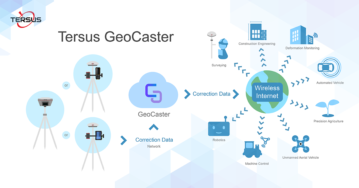
“The Tersus Networked Transport of RTCM via Internet Protocol (NTRIP) Caster Software is designed to allow GNSS correction data such as RTCM corrections to be repeated and sent to different end users via the internet,” said Xiaohua Wen, Founder&CEO of Tersus GNSS Inc. “GeoCaster has a user-friendly interface and it not only supports multiple bases online simultaneously but also supports multiple rovers for one base. Our users can have a real-time review of detailed statistics and can modify user-defined permissions manually.”

The Tersus GeoCaster supports configurable bases online simultaneously and configurable rovers for one base. GeoCaster supports Ntrip protocol and it has 7X24 hours operation.

The end users involved in various applications including surveying, construction engineering, deformation monitoring, automated vehicle, precision agriculture, Unmanned Aerial Vehicle, machine control, robotics, and etc.

It's the first release of GeoCaster 1.0. By the time of version 2.0 release, VRS or Vbase functions are ready, it can be much higher accuracy and longer baseline application. GeoCaster 2.0 is targeted at Q1 2019, stay tuned.

For more product information:
Tersus GeoCaster, click here.  
Tersus GeoBee, click here.

About Tersus GNSS Inc.

Tersus is a leading GNSS RTK solution provider. Our engineers have been pioneers in the design of GNSS products to support high-precision positioning applications.
Our products include GNSS RTK & PPK OEM boards and receivers, as well as integrated solutions such as the David GNSS Receiver, Oscar Receiver, MatrixRTK, and GNSS-aided Inertial Navigation System.
Designed for easy and rapid integration, our GNSS solutions offer centimeter-level positioning accuracy and flexible interfaces for a variety of applications including: unmanned aerial vehicle (UAVs), surveying, mapping, construction engineering, and precision agriculture.

Sales inquiry : sales@tersus-gnss.com
Technical support : support@tersus-gnss.com

Comments

Popular posts from this blog

Tersus Geomatics Office - Static Surveying - Data Processing

Tersus Geomatics Office is integrated office software to manage and process data for NeoRTK, the RTK survey receiver. It is laid out with visualized toolbars and logical icons to easily handle GNSS data processing, baseline processing and network adjustment, etc. It is the software set to import, update and analyze data effectively.  Watch the video to know how to do data processing after static surveying data collection with NeoRTK.  Learn more, click here .  Inquiry, click here . 

How to Use Oscar to Collect Static Data for A Given Length of Time

Usually, we need to collect static data for a given length of time, for example, 2 hours. In the past, the surveyor had to record the start time and keep an eye on the clock all the time. The function of setting the static collection duration in Oscar GNSS Receiver can solve this problem. When setting the static survey, the surveyor only needs to enter the duration time, then start it, and no more attention will be required. When the time is up, Oscar will automatically stop recording, with no fewer or more data. Now we show you how to set the Oscar static collection duration on the OLED display of Oscar. 1. Turn on the Oscar, press the Power ON/OFF button and Function (FN) button, and go to Mode Config -> Static. The default option of Static is OFF, and you can press the Function (FN) button to switch it to “Auto” or “Manual”. 2. Go to Duration to set the collection time, for example, 120 minutes. 3. Set other options, then choose “Confirm”, and it will start to collect st...

What is CORS network? How to connect to CORS network with external Bluetooth module and mobile phone?

A CORS is a Continuously Operating Reference Station. The CORS is an appealing way to do RTK due to its convenience and large coverage area. While Tersus Precis-BX305 currently does not support build-in NTRIP client feature. An alternative way to connect CORS network is employing external Bluetooth module and a cellphone. Here is a detailed procedure about how to connect to CORS Network with Precis-BX305 board.  Demonstration of connecting Precis BX305 to CORS Network Hardware & Software Requirement Precis-BX305 GNSS antenna GNSS antenna cable  External Bluetooth module Bluetooth cable Cell phone (android system) 5V DC charger Software required Ntrip client (free android apps)    Connect to CORS Network Please follow below steps.  Connect GNSS antenna to Precis-BX305. Connect external Bluetooth module to either COM1 or COM2 of the board Connect to power supplier and plug in/turn on the power Turn on the Bluetooth of the mobil...