Today we are going to introduce a hidden feature of Tersus Oscar receiver -- How to check the signal strength on Oscar screen.

If we work in the field, and fail to configure Oscar to rover mode, we can check if the signal strength of the network is good enough on Oscar screen. Here are the steps:
1. Press the Power ON/OFF button and Function (FN) button, go to Device info. Make sure the Cellular is on. The Cellular will not be turned on automatically when Oscar is turned on, you can configure Oscar to rover network mode to turn on it.
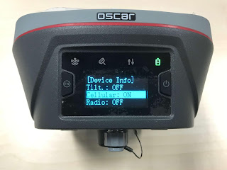
2. Go to Device Info-Cellular to check the signal strength.
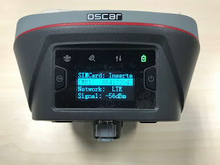
The following is a rough guide to signal strength (dBm):
• -50 to -40 means an excellent signal (your Oscar is close to a base station).
• -60 to -50 indicates a very good signal.
• -70 to -60 shows good signal.
• -80 to -70 means less weak signals.
• -90 to -80 shows weak signal.
• Above -90 indicates basic communication is possible.
• Under -90 means your Oscar network connection may be intermittent.
Note: The cellular frequencies of different telecommunications operator may be different, please make sure that the frequencies of your sim card match with Oscar.
Read the tip:
https://groups.google.com/forum/#!topic/tersus-gnss-community/_afv0eRyaOA
#geospatial #surveyor #landsurvey #GNSS #receiver
Usually, we can insert a sim card to Oscar and work with receiver network mode.

If we work in the field, and fail to configure Oscar to rover mode, we can check if the signal strength of the network is good enough on Oscar screen. Here are the steps:
1. Press the Power ON/OFF button and Function (FN) button, go to Device info. Make sure the Cellular is on. The Cellular will not be turned on automatically when Oscar is turned on, you can configure Oscar to rover network mode to turn on it.

2. Go to Device Info-Cellular to check the signal strength.

The following is a rough guide to signal strength (dBm):
• -50 to -40 means an excellent signal (your Oscar is close to a base station).
• -60 to -50 indicates a very good signal.
• -70 to -60 shows good signal.
• -80 to -70 means less weak signals.
• -90 to -80 shows weak signal.
• Above -90 indicates basic communication is possible.
• Under -90 means your Oscar network connection may be intermittent.
Note: The cellular frequencies of different telecommunications operator may be different, please make sure that the frequencies of your sim card match with Oscar.
Read the tip:
https://groups.google.com/forum/#!topic/tersus-gnss-community/_afv0eRyaOA
#geospatial #surveyor #landsurvey #GNSS #receiver
This comment has been removed by the author.
ReplyDeleteHi, i have Oscar Basic. Normaly i use the phone app and net of the phone to work, and start ntrip with option "Pda Network" and work great. Here my question... i will put my Sim card on the Oscar Basic to start the Ntrip, then i have to start "Receiver Network"... its possible to the Oscar automacaly know already have the Sim card?! How can i do to start with Sim card on Oscar!?
ReplyDeleteA little help please ;)