Once the registration period of Oscar GNSS receiver expires, RTK mode of the receiver will be banned. Using Nuwa software or using the panel to set Oscar to base mode or rover mode will fail. At this time, Oscar needs to be additionally registered to extend its effective period.
Additional registration for Oscar does not require access to web pages, internal systems, or other operations that require remote assistance. You only need to have an Android controller with Nuwa app installed.
1. First apply to Tersus for an additional registration permission. Once permitted, Tersus will send you the following characters.
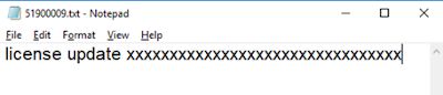
license update 1ADC………………C533
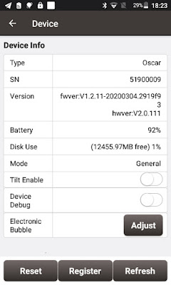
2. Create a new text file with the suffix txt. The file name is the eight digit SN of the Oscar to be registered. If you are not sure what the eight digit SN of the receiver is, you can use Nuwa to connect with this Oscar and check the eight digit SN under Device interface. Then copy the characters from the first step and paste it in a text file and save.
3. Copy the text file to TersusSurvey directory in the Android controller.
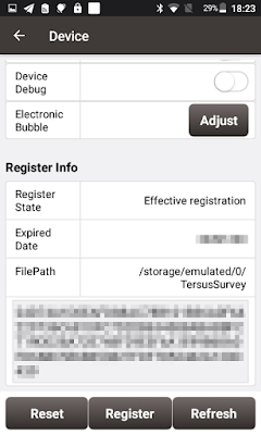
4. Use Nuwa app to connect the Oscar to be registered and enter the Device interface. It will display the current registration status has expired and the expired date. Click Register, Nuwa will automatically recognize the registration code from the text file in the TersusSurvey directory to complete Oscar registration via Bluetooth.
Additional registration for Oscar does not require access to web pages, internal systems, or other operations that require remote assistance. You only need to have an Android controller with Nuwa app installed.
1. First apply to Tersus for an additional registration permission. Once permitted, Tersus will send you the following characters.
license update 1ADC………………C533
2. Create a new text file with the suffix txt. The file name is the eight digit SN of the Oscar to be registered. If you are not sure what the eight digit SN of the receiver is, you can use Nuwa to connect with this Oscar and check the eight digit SN under Device interface. Then copy the characters from the first step and paste it in a text file and save.

3. Copy the text file to TersusSurvey directory in the Android controller.

4. Use Nuwa app to connect the Oscar to be registered and enter the Device interface. It will display the current registration status has expired and the expired date. Click Register, Nuwa will automatically recognize the registration code from the text file in the TersusSurvey directory to complete Oscar registration via Bluetooth.

Comments
Post a Comment