Complete the Base Shift Quickly

 Complete the Base Shift Quickly

Few steps to complete the base shift

In ‘ Auto Start ’ mode for base station, if the base is moved, re-erected or restarted at an unknown point, base shift should be performed to ensure the points collected by the current base station is consistent with that before the base is moved or powered off. Briefly, find a known point, measure the coordinates of this point, then use this point to calculate the offset of the base shift, apply the base shift to all the survey points under the current base coordinates to make the reference coordinate system of the base remains the same as the previous base station.

The detailed steps are as follows:

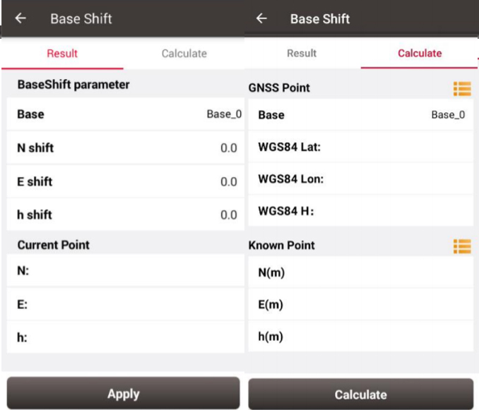
1. Click [Base Shift] to enter the following interface, Figure 1 shows the calculation result for the base shift; Figure 2 shows the source of the base shift calculation.
tersus oscar baseshift.jpg


2. Click the list icon on the right of GNSS Point to select a survey point which is measured at the known point and click the list icon on the right of Known Point to select a known point in the control point library (details of control point refers to section 2.4 Point).

3. Click [Calculate] and the base shift is calculated automatically.

4. Click [Apply] to apply the base shift to all the points surveyed and to be surveyed under the current base station.

At this time, select the base point in the survey point library to view the details. It can be found that the current NEh shift amount is recorded in the base point information, and the NEh coordinates of all the survey points under this base station change accordingly.

If you need to reset (cancel) the base shift, just enter [base shift], and manually modify the three parameters of north shift, east shift and height shift to 0. At this time, return to the survey point library to view the details of the base point. The NEh shift amount in the base point information is automatically changed to 0, and all survey points NEh coordinates under the base station are restored to the coordinates before the base shift.

Support

Should you need any technical support, please contact us without hesitation. support@tersu-gnss.com 


Comments

Popular posts from this blog

Tersus Geomatics Office - Static Surveying - Data Processing

Tersus Geomatics Office is integrated office software to manage and process data for NeoRTK, the RTK survey receiver. It is laid out with visualized toolbars and logical icons to easily handle GNSS data processing, baseline processing and network adjustment, etc. It is the software set to import, update and analyze data effectively.  Watch the video to know how to do data processing after static surveying data collection with NeoRTK.  Learn more, click here .  Inquiry, click here . 

What is CORS network? How to connect to CORS network with external Bluetooth module and mobile phone?

A CORS is a Continuously Operating Reference Station. The CORS is an appealing way to do RTK due to its convenience and large coverage area. While Tersus Precis-BX305 currently does not support build-in NTRIP client feature. An alternative way to connect CORS network is employing external Bluetooth module and a cellphone. Here is a detailed procedure about how to connect to CORS Network with Precis-BX305 board.  Demonstration of connecting Precis BX305 to CORS Network Hardware & Software Requirement Precis-BX305 GNSS antenna GNSS antenna cable  External Bluetooth module Bluetooth cable Cell phone (android system) 5V DC charger Software required Ntrip client (free android apps)    Connect to CORS Network Please follow below steps.  Connect GNSS antenna to Precis-BX305. Connect external Bluetooth module to either COM1 or COM2 of the board Connect to power supplier and plug in/turn on the power Turn on the Bluetooth of the mobile phone and scan and pai

What is the principle of GNSS positioning?

Satellite based positioning relies on measuring distance between satellite and receivers. With known satellite position and measured distance between satellite and receiver, the coordinate of receiver can be calculated. However, the electromagnetic signals emitted by satellites are perturbed by atmosphere and clock errors, which degrade GNSS positioning accuracy. There are two types of positioning mode, one is point position and the other is relative position (see Fig 1). Point positioning includes standard point positioning (SPP) and precise point positioning (PPP). Their major difference is whether use the carrier phase observation. Relative positioning also includes two types: DGPS and RTK. Their difference is the latter one uses carrier phase observation as well. Relative positioning cancels most error sources in distance measurement by making difference between two receivers, so it is more simple and reliable, but it only measures relative position. In practice, the coordinate of